N 46° 29.232′ W 93° 58.417′ There is an old snowmobile off the boat access at Portsmouth Mine pit at about 30′ deep. I only dove this at night so the visibility was not verified. The snowmobile is near the end of the second video.
N 46° 29.566′ W 93° 59.024′ At the South side of Hopkins Mine pit is a non-formal campsite that has some good shore diving just a few feet away. There are some submerged trees and some train track rails scattered around. We practiced lift bags here on a 40′ long train rail. Visibility here is about 30′.
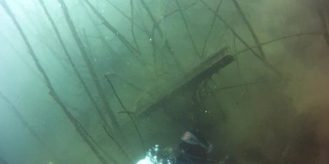
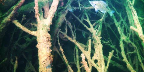
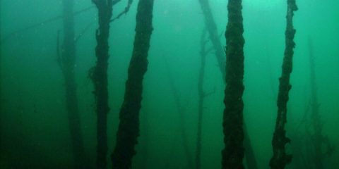
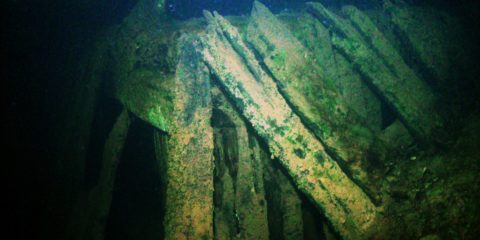
N 46° 28.753′ W 94° 0.152′ The submerged forest in Huntington Mine Pit primarily runs along the South side. Pulling a diver through the trees on a tow sled at 3 MPH is a trip.
N 46° 28.998′ W 94° 0.645′ The submerged forest at Alstead South Mine pit was created when the Iron Ore ran out and the mining companies quit pumping out the mine, the pit flooded. The visibility here is about 30′.
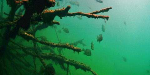
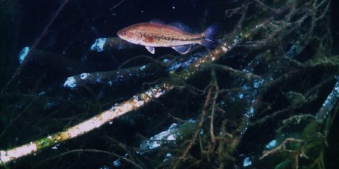
N 46° 28.522′ W 94° 1.108′ The beaver lodge at the West end of Huntington Mine pit is a fish magnet. It is at 30′ deep and extends all the way to the surface. The visibility here is usually about 30′
N 46° 28.664′ W 94° 0.702′ This dump truck was stolen and launched into the Huntington Mine pit off a steep hill. It tumbled down an underwater wall and stopped on its side at 105′ deep. The visibility here is about 20′ but very dark and cold.
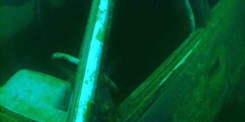
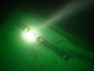
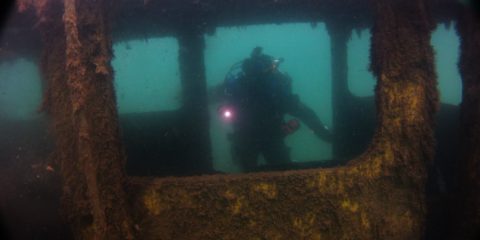
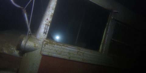
N 46° 28.671′ W 94° 0.697′ This was a ford van that was stolen from the City of Crosby Water Works Department. The City Police wanted us to recover the only map known to exist that showed where the water valves are in Crosby. We looked many different times for the maps and did not find them. We did recover the tools for the City though. It was sitting at 105′ deep but the van has since has been recovered. There is a debris trail up the hill of stuff.
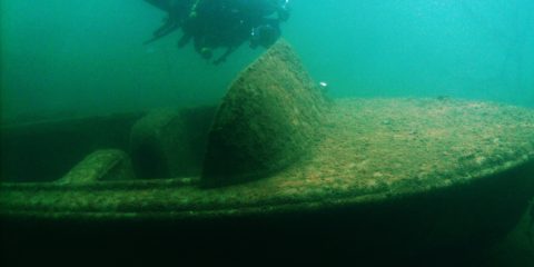
N 46° 28.806′ W 94° 0.251′ Gilligans Plunge is a dive site where someone placed a fiberglass boat at 30′ deep on the North side of Huntington Mine pit. Just over the ledge from here, at about 110′ deep, there is a Ford Ranger with a topper, but I have not dove that one yet.
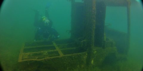
N 46° 28.449′ W 94° 1.070′ Gettin’ the Shaft is the name of a dive site that is a vertical mine shaft that has a wood structure around the top of the shaft at about 10′ deep. The shaft is lined with wood timbers and extends down very deep. We dropped a camera down it once but it is too fragile to get a diver in there.
N 46° 29.231′ W 94° 0.617′ This is Arco Mine Pit. The trees grew during the time the pit was dry. When the mine closed down, the pumps were turned off and the mine pit flooded leaving the submerged forest around the edges. The visibility is around 30′. The depth of the submerged forest is from 5′ to 40′ deep.
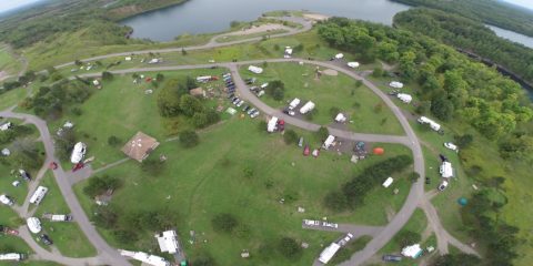
N 47° 29.042′ W 92° 27.817′ Scuba Palooza is a two day annual treasure dive event that brings divers from all over Minnesota to find underwater medallions, watch home videos of dives, eat BBQ, camp, and just hang out. It is at the Sherwood Forest Campground at Gilbert, MN.
N 47° 28.736′ W 92° 27.555′ There are 3 lines at this buoy. One leads to a twin engine plane, the next leads to a Huey Chopper, and the 3rd one leads to a 1940’s car. They are between 25′ and 40′ deep. The visibility here varies from 20′ to 40′.
N 47° 28.881′ W 92° 27.794′ The Rail truck is like a pick up truck that would run on the rails to haul small train cars into and out of the mine pit. These were electric and ran of a series of batteries under the bed. The rail truck is sitting in 28′ deep water straight out from where the kids would jump off the cliff. The visibility here is about 20′.
N 47° 28.894′ W 92° 27.745′ Rail Speeder #2 is a gas powered rail car made to transport miners in and out of the open pit mine. There are two of these in Lake Ore-B-Gone but this one is at 21′ deep. The visibility here is about 25′.
N 47° 28.897′ W 92° 27.726′ Rail Speeder #1 is a gas powered rail car made to transport miners in and out of the open pit mine. There are two of these in Lake Ore-B-Gone but this one is at 20′ deep. The visibility here is about 25′.
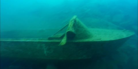
N 47° 28.895′ W 92° 27.713′ This fiberglass boat is sitting on a rocky slope just off the swimming beach in 40 deep water. Because the mine pit is 433′ deep, the water can be chilly at depth. The visibility here is about 25′.
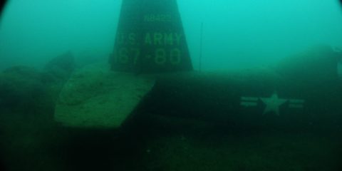
N 47° 28.895′ W 92° 27.695′ The small single engine Army trainer plane is sitting on a rocky slope at 41′ deep. The canopy is open but it is too tight to fit a diver in there. Because the mine pit is 433′ deep, the water can be chilly at depth. Visibility here is about 25′.
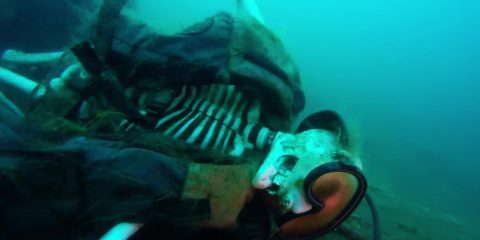
N 47° 28.908′ W 92° 27.673′ This fake skeleton is sitting on a pump platform at 52′ deep. Someone in the past dressed it up in scuba gear and sat it on a lawn chair. The visibility here is about 25′ Because the mine pit is 433′ deep, the water is chilly here at depth.
N 47° 29.022′ W 92° 27.684′ I think this Jeep in the water was an accident based on the crumpled condition and the steep hill it rolled down. It is in 15′ of water. The visibility here is about 30′.
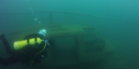
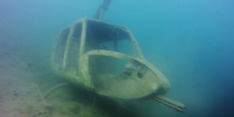
N 47° 29.038′ W 92° 27.667′ This is a helicopter that has a replica mini-gun mounted on the nose. It is sitting at 35′ deep but because the mine pit is 433′ deep, the dives here are chilly. Visibility is about 40′.
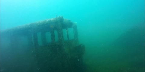
N 47° 29.073′ W 92° 27.642′ The School bus is silver and maroon and its sitting on a 45 degree slope from back to front. The back is at 54′ deep and the front is at 40′ deep. The back door is open so you can swim through it. Visibility here is about 40′. This is a deep mine pit at 433′ deep so the water temps are usually chilly at depth.
N 47° 32.077′ W 92° 13.799′ The wall is just East of the boat launch in St. James mine pit. Although the mine pit is 381′ deep the wall drops to 220′. I only went down to about 110′ but the visibility was so good, I didn’t need a light at that depth. Visibility was about 50′.
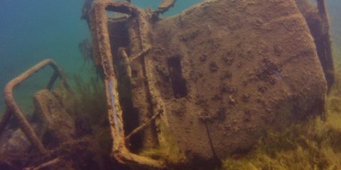
N 47° 32.381′ W 92° 17.141′ Although the mine pit is 465′ deep, these submerged buildings sit at 75′ deep on top of a ledge that drops very deep. The visibility was about 35′

 for more information about the location.